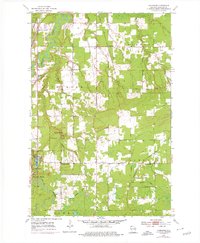
1954 Map of Sunnyside
USGS Topo · Published 1976About this map
Pattison State Park serves as a focal point of this Douglas County landscape, where the Black River creates the dramatic Big Manitou Falls before flowing north toward Lake Superior. The 1954 data, photorevised in 1975, reveals a rural network of small community centers such as Boylston Junction and Sunnyside, each connected by a mix of functional infrastructure and natural waterways. Educational and religious life is marked by local landmarks like Oakland Sch and Manitou Falls Ch, while the industrial history of the region is etched into the terrain via the Soo Line and an Old Railroad Grade further south. The drainage patterns of Crawford Cr and the Nemadji River illustrate the transition from the high falls area to the lower plains, providing a detailed look at the hydrology and early mid-century settlement patterns in Oakland and Superior townships.
Find a feature on this map
33 named features on this map. Tap any name to fly to it.
Don’t see what you’re looking for? This feature index may not catch every label — zoom into the map to look around manually.
Map Details
Editions of this 1954 Sunnyside Map
2 editions found

Other maps of this area

1915 · Superior
USGS Topo · 1:48,000

1917 · Superior
USGS Topo · 1:62,500

1945 · Solon Springs
USGS Topo · 1:48,000

1949 · Solon Springs
USGS Topo · 1:48,000

1949 · Patzau
USGS Topo · 1:48,000

1949 · Poplar
USGS Topo · 1:48,000

1953 · Ashland
USGS Topo · 1:250,000

1953 · Duluth
USGS Topo · 1:250,000

1954 · West Duluth
USGS Topo · 1:24,000

1954 · Borea
USGS Topo · 1:24,000