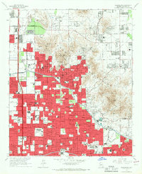
1965 Map of Sunnyslope
USGS Topo · Published 1967About this map
Sunnyslope and the northern reaches of Phoenix are captured here during a period of rapid mid-century suburban expansion. The urban footprint, indicated by dense red tinting, pushes northward toward the Phoenix Mountains, where landmarks like North Mountain and Squaw Peak still provide a natural barrier to development. This era of growth is anchored by the Arizona Canal, which snakes through the valley, separating established residential blocks from the more open Paradise Valley and Deer Valley to the north.
Find a feature on this map
88 named features on this map. Tap any name to fly to it.
Don’t see what you’re looking for? This feature index may not catch every label — zoom into the map to look around manually.
Map Details
Editions of this 1965 Sunnyslope Map
4 editions found
Other maps of this area

1904 · Camelback
USGS Topo · 1:62,500

1906 · Camelsback
USGS Topo · 1:62,500

1912 · Phoenix
USGS Topo · 1:62,500

1913 · Mesa
USGS Topo · 1:62,500

1914 · Phoenix
USGS Topo · 1:62,500

1915 · Mesa
USGS Topo · 1:62,500

1930 · Cave Creek
USGS Topo · 1:125,000

1939 · Cave Creek
USGS Topo · 1:125,000

1952 · Tempe
USGS Topo · 1:24,000

1952 · Phoenix
USGS Topo · 1:24,000