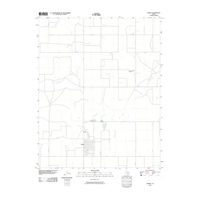
2010 Map of Sunray
USGS Topo · Published 2010About this map
Sunray sits at the heart of this High Plains landscape, where the grid of Moore County roads reveals a region defined by agricultural and industrial connectivity. This 2010 survey shows the town's organized layout just south of Sunray Airport, illustrating its role as a local center for the surrounding plains. The terrain is marked by the winding path of North Palo Duro Creek, which provides a natural break in the geometric precision of the farm-to-market road system. Local history and genealogy are anchored by the Lane Memorial Cemetery located north of the town center. The presence of specialized routes like Light Plant Rd and Texas Reef Rd suggests the influence of local utility infrastructure and regional industry on the development of the road network. These features, alongside private aviation landmarks like Roy Browder Airport, depict a modern Texas Panhandle community where vast space is bridged by a combination of rural highways and local aviation.
Find a feature on this map
18 named features on this map. Tap any name to fly to it.
Don’t see what you’re looking for? This feature index may not catch every label — zoom into the map to look around manually.
Map Details
Editions of this 2010 Sunray Map
This is the sole edition of this map. No revisions or reprints were ever made.
Other maps of this area

1954 · Perryton
USGS Topo · 1:250,000

1954 · Amarillo
USGS Topo · 1:250,000

1958 · Perryton
USGS Topo · 1:250,000

1958 · Amarillo
USGS Topo · 1:250,000

1963 · Cactus East
USGS Topo · 1:24,000

1965 · Spurlock Chapel
USGS Topo · 1:24,000
1965 · Dumas North
USGS Topo · 1:24,000

1972 · Dumas NE
USGS Topo · 1:24,000

1972 · Capps Switch
USGS Topo · 1:24,000

1972 · Sunray
USGS Topo · 1:24,000