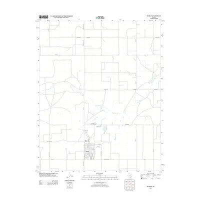
2012 Map of Sunray
USGS Topo · Published 2012About this map
Sunray occupies the heart of this High Plains landscape, showcasing a grid of residential and industrial development in the early 21st century. The town's layout is meticulously detailed, from the named thoroughfares like Avenue J and E 5th St to the local Sunray Airport situated on its western edge. North of the primary settlement, the winding course of N Palo Duro Cr breaks the geometric regularity of the surrounding section roads and ranch land. This map records the essential infrastructure of a Texas Panhandle community, highlighting significant local sites such as the Lane Memorial Cem on Cemetery Rd. The network of transit routes, including Ranch Road 119 and Texas Beef Rd, underscores the region's agricultural and industrial priorities during this era.
Find a feature on this map
32 named features on this map. Tap any name to fly to it.
Don’t see what you’re looking for? This feature index may not catch every label — zoom into the map to look around manually.
Map Details
Editions of this 2012 Sunray Map
This is the sole edition of this map. No revisions or reprints were ever made.
Other maps of this area

1954 · Perryton
USGS Topo · 1:250,000

1954 · Amarillo
USGS Topo · 1:250,000

1958 · Perryton
USGS Topo · 1:250,000

1958 · Amarillo
USGS Topo · 1:250,000

1963 · Cactus East
USGS Topo · 1:24,000

1965 · Spurlock Chapel
USGS Topo · 1:24,000
1965 · Dumas North
USGS Topo · 1:24,000

1972 · Dumas NE
USGS Topo · 1:24,000

1972 · Capps Switch
USGS Topo · 1:24,000

1972 · Sunray
USGS Topo · 1:24,000