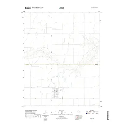
2019 Map of Sunray
USGS Topo · Published 2019About this map
Sunray serves as the primary hub of this High Plains landscape, organized by a precise grid of farm-to-market roads and county lines. The town's residential layout is clearly defined by numbered streets from E 2nd St to E 10th St, supported by local infrastructure like the Sunray Airport and the descriptively named Light Plant Rd. The surrounding Moore County terrain is bisected by the winding course of N Palo Duro Cr, which creates the only significant break in the flat agricultural geometry. Local history is anchored by the Brown Cem and Lane Memorial Cem located just north of the town center. The industrial character of the region is further hinted at by the presence of Texas Beef Rd, reflecting the cattle-driven economy that defines this portion of the Texas Panhandle.
Find a feature on this map
28 named features on this map. Tap any name to fly to it.
Don’t see what you’re looking for? This feature index may not catch every label — zoom into the map to look around manually.
Map Details
Editions of this 2019 Sunray Map
This is the sole edition of this map. No revisions or reprints were ever made.
Other maps of this area

1954 · Perryton
USGS Topo · 1:250,000

1954 · Amarillo
USGS Topo · 1:250,000

1958 · Perryton
USGS Topo · 1:250,000

1958 · Amarillo
USGS Topo · 1:250,000

1963 · Cactus East
USGS Topo · 1:24,000

1965 · Spurlock Chapel
USGS Topo · 1:24,000
1965 · Dumas North
USGS Topo · 1:24,000

1972 · Dumas NE
USGS Topo · 1:24,000

1972 · Capps Switch
USGS Topo · 1:24,000

1972 · Sunray
USGS Topo · 1:24,000