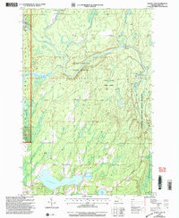
1999 Map of Sunset Lake
USGS Topo · Published 2004About this map
Ottawa National Forest and the Copper Country State Forest converge in this northern Michigan landscape, where the Paint River winds through Iron County. This 1999 revision reveals a transition from industrial and utility land use to recreational forest management. While a Paint Dam (Abandoned) and a Gravel Pit represent earlier resource extraction and engineering, the presence of a Canoe Access and Me-Squa-Gum-E Park highlights the area's shift toward public timberlands and waterway access.
Find a feature on this map
22 named features on this map. Tap any name to fly to it.
Don’t see what you’re looking for? This feature index may not catch every label — zoom into the map to look around manually.
Map Details
Editions of this 1999 Sunset Lake Map
This is the sole edition of this map. No revisions or reprints were ever made.
Other maps of this area

1895 · Ned Lake
USGS Topo · 1:62,500

1895 · Perch Lake
USGS Topo · 1:62,500

1898 · Iron River
USGS Topo · 1:62,500

1899 · Crystal Falls
USGS Topo · 1:62,500

1944 · Iron River
USGS Topo · 1:24,000

1944 · Gaastra
USGS Topo · 1:24,000

1944 · Fortune Lakes
USGS Topo · 1:24,000

1945 · Gibbs City
USGS Topo · 1:24,000

1945 · Sunset Lake
USGS Topo · 1:24,000

1945 · Amasa
USGS Topo · 1:24,000