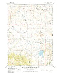
1957 Map of Sunshine Reservoir
USGS Topo · Published 1984About this map
The Greybull River cuts a prominent path through this high-country landscape, serving as the central artery for a ranching and energy-producing economy in the mid-1950s. The map documents an extensive network of irrigation infrastructure essential for high-altitude agriculture, including the Long Hollow Ditch, Joe Moss Ditch, and Sunshine River Ditch. These waterways support several family-named ranching operations such as the Thomas Ranch, Z Bar T Ranch, and Palette Ranch.
Find a feature on this map
54 named features on this map. Tap any name to fly to it.
Don’t see what you’re looking for? This feature index may not catch every label — zoom into the map to look around manually.
Map Details
Editions of this 1957 Sunshine Reservoir Map
2 editions found

Other maps of this area

1904 · Kirwin
USGS Topo · 1:125,000

1906 · Kirwin
USGS Topo · 1:125,000

1911 · Meeteetse
USGS Topo · 1:62,500

1911 · Oregon Basin
USGS Topo · 1:62,500

1913 · Oregon Basin
USGS Topo · 1:62,500

1913 · Meeteetse
USGS Topo · 1:62,500

1955 · Cody
USGS Topo · 1:250,000

1955 · Thermopolis
USGS Topo · 1:250,000

1956 · Soapy Dale Peak
USGS Topo · 1:24,000

1957 · Wapiti
USGS Topo · 1:62,500