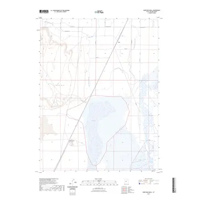
2023 Map of Sunstone Knoll
USGS Topo · Published 2023About this map
Sunstone Knoll rises above the basin floor in this high-desert portion of Millard County, characterized by the winding remnants of the Old Channel Sevier River. The landscape is defined by its hydrological features, particularly the expansive Salt Lake and the engineered irrigation of North Ditch. These features suggest a region where water management and the natural course of the Sevier River have historically dictated land use and settlement patterns. The small community of Van sits along a primary north-south corridor, reflecting the sparse but structured development of the area. Distinctive geological markers like Black Rock punctuate the terrain, providing reliable landmarks in an otherwise open, flat basin. This survey illustrates the intricate relationship between the intermittent waterways and the desert topography, capturing the essential character of the region's physical geography.
Find a feature on this map
15 named features on this map. Tap any name to fly to it.
Don’t see what you’re looking for? This feature index may not catch every label — zoom into the map to look around manually.
Map Details
Editions of this 2023 Sunstone Knoll Map
This is the sole edition of this map. No revisions or reprints were ever made.
Other maps of this area

1885 · Sevier Desert
USGS Topo · 1:250,000

1953 · Delta
USGS Topo · 1:250,000

1958 · Delta
USGS Topo · 1:250,000

1962 · Delta
USGS Topo · 1:250,000

1962 · Delta
USGS Topo · 1:62,500

1971 · Pavant Butte North
USGS Topo · 1:24,000

1971 · Neels
USGS Topo · 1:24,000

1971 · Sunstone Knoll
USGS Topo · 1:24,000
1971 · Pot Mountain
USGS Topo · 1:24,000
1971 · Clear Lake
USGS Topo · 1:24,000