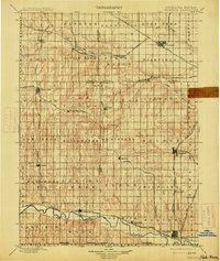
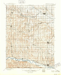
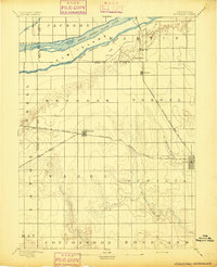
1898 Map of Superior
USGS Topo · Published 1913About this map
The Republican River and the Little Blue River carve through this section of south-central Nebraska, defining a landscape of transition where the Blue Valley gives way to upland prairies. Surveyed in the early 1890s, this area is characterized by a dense network of competing rail lines, reflecting the rapid expansion of the late nineteenth century. Major arteries such as the St. Joseph and Grand Island R. R. and the Burlington and Missouri River R. R. intersect near established hubs like Nelson and Fairfield. A detailed grid of townships—including Spring Ranch, Liberty, and Victor—organizes the territory, while smaller rail-side settlements like Guide Rock, Bostwick, and Mt. Clare show the era's reliance on steam transport for trade and travel. The map also records the precise Nebraska Kansas boundary, marking the southern edge of the survey where the Bur. and Mo. Riv. R. R. Branch crosses into the neighboring state.
Find a feature on this map
78 named features on this map. Tap any name to fly to it.
Don’t see what you’re looking for? This feature index may not catch every label — zoom into the map to look around manually.
Map Details
Editions of this 1898 Superior Map
3 editions found
Other maps of this area

1892 · Concordia
USGS Topo · 1:125,000

1893 · Smith Center
USGS Topo · 1:125,000

1894 · Mankato
USGS Topo · 1:125,000
1894 · Kenesaw
USGS Topo · 1:62,500

1896 · Wood River
USGS Topo · 1:125,000

1897 · Red Cloud
USGS Topo · 1:125,000

1898 · York
USGS Topo · 1:125,000

1898 · Superior
USGS Topo · 1:125,000

1898 · Hebron
USGS Topo · 1:125,000

1898 · Grand Island
USGS Topo · 1:125,000