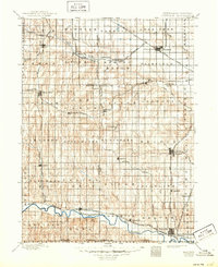
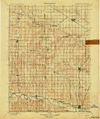
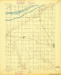
1898 Map of Superior
USGS Topo · Published 1949About this map
Superior and Nelson emerge as critical regional hubs in this late 19th-century survey of south-central Nebraska. The landscape is defined by the complex transit networks of the Republican River and Little Blue River valleys, where numerous railroads, including the Kansas City and Omaha R. R. and the Nelson Branch, converge. This era shows a high density of rural settlements and post offices such as Spring Ranch, Pauline, and the small community of St. Stephen, illustrating the rapid agricultural expansion and rail-driven development following the initial prairie surveys.
Find a feature on this map
77 named features on this map. Tap any name to fly to it.
Don’t see what you’re looking for? This feature index may not catch every label — zoom into the map to look around manually.
Map Details
Editions of this 1898 Superior Map
3 editions found
Other maps of this area

1892 · Concordia
USGS Topo · 1:125,000

1893 · Smith Center
USGS Topo · 1:125,000

1894 · Mankato
USGS Topo · 1:125,000
1894 · Kenesaw
USGS Topo · 1:62,500

1896 · Wood River
USGS Topo · 1:125,000

1897 · Red Cloud
USGS Topo · 1:125,000

1898 · York
USGS Topo · 1:125,000

1898 · Superior
USGS Topo · 1:125,000

1898 · Hebron
USGS Topo · 1:125,000

1898 · Grand Island
USGS Topo · 1:125,000