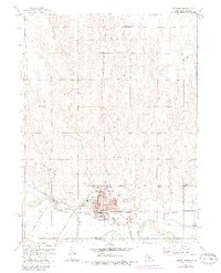
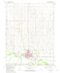
1974 Map of Superior
USGS Topo · Published 1984About this map
The Republican River defines the southern reach of this Nebraska-Kansas borderland, where the city of Superior serves as a significant regional hub for transportation and water management. A complex network of engineering is visible along the river, including a Canal, Siphon, and Flume, supporting the local infrastructure alongside the Waterworks and Sewage Disposal facilities. North of the state line, the landscape is dotted with smaller rural centers and social markers like Abdal, Smyrna, and Cadams. Educational history is well-preserved through the locations of the North Ward Sch, South Ward Sch, and the more remote Beaver-Ville Sch. Rail activity remains a central theme, with the Burlington Northern, Atchison Topeka and Santa Fe, and Missouri Pacific RR converging near the city, while an Old RR Grade and an Industrial Line mark the evolving path of trade through Nuckolls County.
Find a feature on this map
35 named features on this map. Tap any name to fly to it.
Don’t see what you’re looking for? This feature index may not catch every label — zoom into the map to look around manually.
Map Details
Editions of this 1974 Superior Map
2 editions found
Other maps of this area

1892 · Concordia
USGS Topo · 1:125,000

1894 · Mankato
USGS Topo · 1:125,000

1898 · Superior
USGS Topo · 1:125,000

1898 · Hebron
USGS Topo · 1:125,000

1955 · Manhattan
USGS Topo · 1:250,000

1955 · Lincoln
USGS Topo · 1:250,000

1955 · Grand Island
USGS Topo · 1:250,000

1955 · Beloit
USGS Topo · 1:250,000

1956 · Manhattan
USGS Topo · 1:250,000

1957 · Manhattan
USGS Topo · 1:250,000