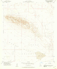
1956 Map of Superstition Mtn.
USGS Topo · Published 1958About this map
Superstition Mountain dominates the landscape of this mid-1950s Imperial Valley survey, rising sharply above the surrounding West Mesa. The map captures a rugged desert environment largely dedicated to military use, specifically within the expansive Naval Reservation that covers much of the southern half of the sheet. Within this area, a specific Target Area and various Jeep Trails suggest active use by the military during the Cold War era. Resource extraction and prospecting are also evident on the mountain's eastern slopes, where a Quarry and Prospect are noted. The presence of a Dry Lake south of the mountain underscores the arid climate of this part of California, where natural landmarks like Mosca and the Superstition peak served as essential navigational points for those traversing the desert before modernization.
Find a feature on this map
10 named features on this map. Tap any name to fly to it.
Don’t see what you’re looking for? This feature index may not catch every label — zoom into the map to look around manually.
Map Details
Editions of this 1956 Superstition Mtn. Map
4 editions found
Other maps of this area

1915 · El Centro
USGS Topo · 1:125,000

1940 · Brawley
USGS Topo · 1:62,500

1940 · Kane Spring
USGS Topo · 1:62,500

1940 · Plaster City
USGS Topo · 1:62,500

1942 · El Centro
USGS Topo · 1:250,000

1943 · Brawley
USGS Topo · 1:62,500

1944 · Plaster City
USGS Topo · 1:62,500

1944 · Kane Spring
USGS Topo · 1:62,500

1944 · Calipatria
USGS Topo · 1:62,500

1954 · El Centro
USGS Topo · 1:250,000