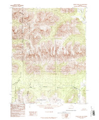
1986 Map of Survey Pass A-2
USGS Topo · Published 1986About this map
The Continental Divide creates a sharp topographical partition across this Brooks Range landscape, marking a boundary that separates the Gates of the Arctic National Park and its National Wilderness to the north from the National Preserve to the south. The transition from high mountain peaks to more moderate elevations is evident in the Helpmejack Hills, which dominate the southern portion of the sheet. Drainage patterns here are defined by the Alatna River and the winding Helpmejack Creek, which flows through the Helpmejack Lake basin. Historically, the Alatna Portage indicates a point of vital overland movement between these drainage systems, providing a window into the traditional navigation of the Yukon-Koyukuk region before contemporary infrastructure was established. This 1986 provisional map was compiled from 1976 aerial photography, recording the untouched character of these protected federal lands.
Find a feature on this map
11 named features on this map. Tap any name to fly to it.
Don’t see what you’re looking for? This feature index may not catch every label — zoom into the map to look around manually.
Map Details
Editions of this 1986 Survey Pass A-2 Map
This is the sole edition of this map. No revisions or reprints were ever made.
Other maps of this area

1951 · Hughes
USGS Topo · 1:250,000

1951 · Survey Pass
USGS Topo · 1:250,000

1956 · Hughes
USGS Topo · 1:250,000

1956 · Survey Pass
USGS Topo · 1:250,000

1964 · Survey Pass
USGS Topo · 1:250,000

1964 · Hughes
USGS Topo · 1:250,000

1965 · Hughes
USGS Topo · 1:250,000

1966 · Survey Pass
USGS Topo · 1:250,000
1986 · Hughes D-1
USGS Topo · 1:63,360
1986 · Survey Pass A-1
USGS Topo · 1:63,360