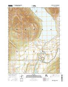
2016 Map of Survey Pass A-3 SW
USGS Topo · Published 2016About this map
Walker Lake serves as the focal point of this northern Alaskan landscape, where the waters of the lake transition into the braided and winding Kobuk River. The terrain is characterized by the convergence of significant protected areas, with the boundary between Gates of the Arctic National Park and the Gates of the Arctic National Preserve bisecting the region. Within the expansive reach of the lake, Swan Island stands as a distinct topographic feature amidst the deep glacial waters and surrounding peaks. This 2016 survey highlights a wilderness area defined by its natural hydrology and the formal demarcation of federal conservation lands, illustrating the modern management of one of the most secluded regions in the United States.
Find a feature on this map
9 named features on this map. Tap any name to fly to it.
Don’t see what you’re looking for? This feature index may not catch every label — zoom into the map to look around manually.
Map Details
Editions of this 2016 Survey Pass A-3 SW Map
This is the sole edition of this map. No revisions or reprints were ever made.
Other maps of this area

1951 · Hughes
USGS Topo · 1:250,000

1951 · Survey Pass
USGS Topo · 1:250,000

1956 · Hughes
USGS Topo · 1:250,000

1956 · Survey Pass
USGS Topo · 1:250,000

1964 · Survey Pass
USGS Topo · 1:250,000

1964 · Hughes
USGS Topo · 1:250,000

1965 · Hughes
USGS Topo · 1:250,000

1966 · Survey Pass
USGS Topo · 1:250,000
1986 · Survey Pass A-4
USGS Topo · 1:63,360
1986 · Hughes D-4
USGS Topo · 1:63,360