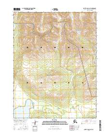
2016 Map of Survey Pass A-4 SE
USGS Topo · Published 2016About this map
Nutuvukti Lake sits in the southwestern portion of this Alaskan interior landscape, where the transition between protected lands defines the local geography. The area is split between the Gates of the Arctic National Park in the northeast and the Gates of the Arctic National Preserve which encompasses the central and southern reaches. This modern survey, compiled from data provided by agencies like the Alaska Dept. of Transportation and the National Hydrography Dataset, depicts a region where political and conservation boundaries intersect with the natural drainage patterns of the Northwest Arctic. The absence of roads or permanent settlements highlights the character of this terrain, showing how public land survey systems like t20n r19e and t19n r20e organize a territory defined primarily by elevation and water.
Find a feature on this map
7 named features on this map. Tap any name to fly to it.
Don’t see what you’re looking for? This feature index may not catch every label — zoom into the map to look around manually.
Map Details
Editions of this 2016 Survey Pass A-4 SE Map
This is the sole edition of this map. No revisions or reprints were ever made.
Other maps of this area

1951 · Hughes
USGS Topo · 1:250,000

1951 · Survey Pass
USGS Topo · 1:250,000

1956 · Hughes
USGS Topo · 1:250,000

1956 · Survey Pass
USGS Topo · 1:250,000

1964 · Survey Pass
USGS Topo · 1:250,000

1964 · Hughes
USGS Topo · 1:250,000

1965 · Hughes
USGS Topo · 1:250,000

1966 · Survey Pass
USGS Topo · 1:250,000
1986 · Survey Pass A-4
USGS Topo · 1:63,360
1986 · Hughes D-4
USGS Topo · 1:63,360