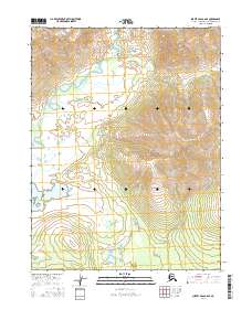
2016 Map of Survey Pass A-6 SE
USGS Topo · Published 2016About this map
The Mauneluk River winds through this interior landscape of the Northwest Arctic Borough, following a serpentine course across the northwest and central portions of the quadrangle. This 2016 survey, published by the U.S. Geological Survey, depicts a largely uninhabited territory defined by the river’s wide meanders and the presence of Avaraart Lake in the southwest. The terrain is characterized by high-elevation contours that rise sharply from the river valley, particularly in the eastern sections within t20n r15e and t19n r15e. The absence of developed roads or structures emphasizes the remote nature of this Arctic region during the early twenty-first century, providing a clear record of the untouched hydrology and landform patterns before any modern human encroachment.
Find a feature on this map
6 named features on this map. Tap any name to fly to it.
Don’t see what you’re looking for? This feature index may not catch every label — zoom into the map to look around manually.
Map Details
Editions of this 2016 Survey Pass A-6 SE Map
This is the sole edition of this map. No revisions or reprints were ever made.
Other maps of this area

1951 · Hughes
USGS Topo · 1:250,000

1951 · Survey Pass
USGS Topo · 1:250,000

1956 · Hughes
USGS Topo · 1:250,000

1956 · Survey Pass
USGS Topo · 1:250,000

1964 · Survey Pass
USGS Topo · 1:250,000

1964 · Hughes
USGS Topo · 1:250,000

1965 · Hughes
USGS Topo · 1:250,000

1966 · Survey Pass
USGS Topo · 1:250,000
1986 · Survey Pass A-5
USGS Topo · 1:63,360
1986 · Hughes D-5
USGS Topo · 1:63,360