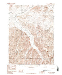
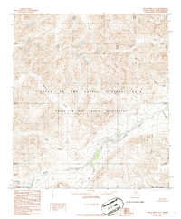
1986 Map of Survey Pass D-4
USGS Topo · Published 1986About this map
The Continental Divide anchors the southern portion of this landscape, marking the high crest where waters part toward separate oceans. This mid-1980s provisional survey, based on 1973 aerial photography, documents the headwaters of the Killik River as it winds north through the heart of the Gates of the Arctic National Park. The topography is dominated by steep drainage systems and tributary waters like April Creek in the northeast. This area, spanning the boundary into the North Slope Borough, remains one of the most preserved wilderness environments in the Brooks Range. The inclusion of the Gates of the Arctic Wilderness designation reflects the era's land conservation efforts following the Alaksa National Interest Lands Conservation Act. The map captures a high-elevation environment where seasonal perennial streams define the shape of the land without the presence of established roads or permanent settlements.
Find a feature on this map
6 named features on this map. Tap any name to fly to it.
Don’t see what you’re looking for? This feature index may not catch every label — zoom into the map to look around manually.
Map Details
Editions of this 1986 Survey Pass D-4 Map
This is the sole edition of this map. No revisions or reprints were ever made.
Other maps of this area

1951 · Survey Pass
USGS Topo · 1:250,000

1951 · Killik River
USGS Topo · 1:250,000

1956 · Survey Pass
USGS Topo · 1:250,000

1956 · Killik River
USGS Topo · 1:250,000

1964 · Survey Pass
USGS Topo · 1:250,000

1966 · Survey Pass
USGS Topo · 1:250,000
1986 · Survey Pass C-3
USGS Topo · 1:63,360
1986 · Killik River A-4
USGS Topo · 1:63,360
1986 · Survey Pass D-5
USGS Topo · 1:63,360
1986 · Killik River A-3
USGS Topo · 1:63,360