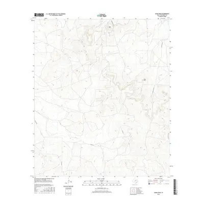
2016 Map of Susan Peak
USGS Topo · Published 2016About this map
Susan Peak and Cedar Knob dominate the interior landscape of this Tom Green County quadrangle, reflecting the prominent topographic relief of this Texas region. The drainage patterns are defined by the winding paths of Lipan Cr, Dry Lipan Cr, and Pecan Cr, which cut through the undulating terrain. A network of specialized thoroughfares, including Marathon Oil Co Rd, Rocking Chair Rd, Dewolf Rd, and Door Key Rd, provides access to the ranching and industrial lands. This infrastructure highlights the historical intersection of cattle culture and resource extraction that has long shaped the local economy. The detailed contouring provides an intimate view of the land's elevation changes, essential for understanding the physical geography of the area.
Find a feature on this map
9 named features on this map. Tap any name to fly to it.
Don’t see what you’re looking for? This feature index may not catch every label — zoom into the map to look around manually.
Map Details
Editions of this 2016 Susan Peak Map
This is the sole edition of this map. No revisions or reprints were ever made.
Other maps of this area

1892 · San Angelo
USGS Topo · 1:125,000

1924 · San Angelo 2-c
USGS Topo · 1:48,000

1928 · Wall
USGS Topo · 1:62,500

1954 · San Angelo
USGS Topo · 1:250,000

1957 · Eola
USGS Topo · 1:62,500

1957 · Wall
USGS Topo · 1:62,500

1958 · San Angelo
USGS Topo · 1:250,000

1965 · San Angelo
USGS Topo · 1:250,000

1970 · Rocking Chair Ranch
USGS Topo · 1:24,000
1970 · Kickapoo Spring
USGS Topo · 1:24,000