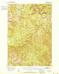
1951 Map of Susanville
USGS Topo · Published 1951About this map
The Middle Fork John Day River carves a significant path through this mid-century landscape, serving as a geographic anchor for the small settlements of Susanville and Galena. This area, situated at the boundary of the Malheur National Forest and Whitman National Forest, reflects a period of active land management and high-country habitation. The map documents numerous isolated outposts and springs, such as the HiYu Guard Station, Herburger Cabin, and several established sites like Cold Spring Camp and Huckleberry Camp.
Find a feature on this map
117 named features on this map. Tap any name to fly to it.
Don’t see what you’re looking for? This feature index may not catch every label — zoom into the map to look around manually.
Map Details
Editions of this 1951 Susanville Map
2 editions found
Other maps of this area

1940 · Mount Vernon
USGS Topo · 1:62,500

1940 · John Day
USGS Topo · 1:62,500

1943 · John Day
USGS Topo · 1:62,500

1943 · Mount Vernon
USGS Topo · 1:62,500

1949 · Long Creek
USGS Topo · 1:62,500

1949 · Susanville
USGS Topo · 1:62,500

1950 · Ritter
USGS Topo · 1:62,500

1951 · Susanville
USGS Topo · 1:62,500

1951 · Long Creek
USGS Topo · 1:62,500

1951 · Dale
USGS Topo · 1:62,500