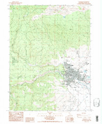
1988 Map of Susanville
USGS Topo · Published 1989About this map
The city of Susanville serves as the focal point of this late-1980s landscape, situated where the Susan River emerges from the surrounding highlands into the broad Honey Lake Valley. The map detail shows the established grid of the city, including its civic and social infrastructure like the Lassen Cemetery, Lassen College, and the County Fairgrounds. To the northwest, the Susanville Rancheria borders the urban edge, while the terrain rises sharply toward Susanville Peak. Water management and industrial land use are evident throughout the area, from the Barry Reservoir and various Aqueduct segments to the Sanitary Disposal Site and Sewage Disposal Plant located southeast of the main settlement. Numerous 4WD trails and resource extraction sites, such as the Gravel Pit near Piute Creek, suggest a landscape defined by both modern municipal growth and the rugged utility of the High Sierra foothills.
Find a feature on this map
33 named features on this map. Tap any name to fly to it.
Don’t see what you’re looking for? This feature index may not catch every label — zoom into the map to look around manually.
Map Details
Editions of this 1988 Susanville Map
2 editions found
Other maps of this area

1886 · Honey Lake
USGS Topo · 1:250,000

1891 · Honey Lake
USGS Topo · 1:250,000

1893 · Honey Lake
USGS Topo · 1:250,000

1954 · Susanville
USGS Topo · 1:62,500

1954 · Fredonyer Peak
USGS Topo · 1:62,500

1955 · Westwood
USGS Topo · 1:62,500

1955 · Westwood
USGS Topo · 1:250,000

1956 · Antelope Mtn
USGS Topo · 1:62,500

1958 · Westwood
USGS Topo · 1:250,000

1959 · Westwood
USGS Topo · 1:250,000