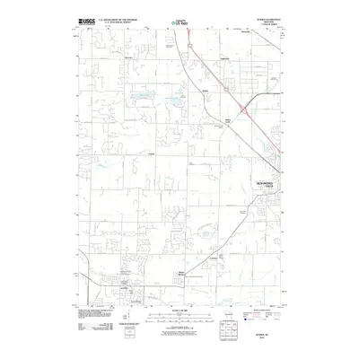
2010 Map of Sussex
USGS Topo · Published 2010About this map
Sussex and Menomonee Falls anchor this survey of suburban and rural Waukesha County at the beginning of the 21st century. The landscape is a mix of established residential grids and glacial terrain, most notably at Zimmermann's Kettle Hills and around Bark Lake and Amy Bell Lake. Significant local history is preserved in the numerous churchyards and burial grounds scattered across the quadrangle, including the Saint Albans Episcopalian Cemetery and the Union Cemetery near Meeker.
Find a feature on this map
74 named features on this map. Tap any name to fly to it.
Don’t see what you’re looking for? This feature index may not catch every label — zoom into the map to look around manually.
Map Details
Editions of this 2010 Sussex Map
This is the sole edition of this map. No revisions or reprints were ever made.
Other maps of this area

1892 · Waukesha
USGS Topo · 1:62,500

1892 · Oconomowoc
USGS Topo · 1:62,500

1901 · Waukesha
USGS Topo · 1:62,500

1904 · West Bend
USGS Topo · 1:62,500

1904 · Hartford
USGS Topo · 1:62,500

1906 · Waukesha
USGS Topo · 1:62,500

1909 · Oconomowoc
USGS Topo · 1:62,500

1957 · Madison
USGS Topo · 1:250,000
1958 · Wauwatosa
USGS Topo · 1:24,000
1958 · Menomonee Falls
USGS Topo · 1:24,000