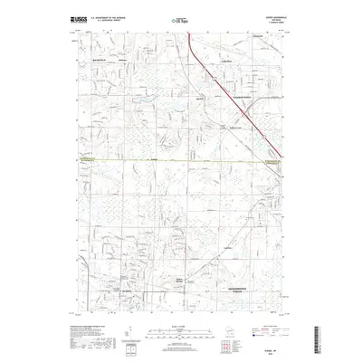
2018 Map of Sussex
USGS Topo · Published 2018About this map
Sussex and Menomonee Falls anchor this 2018 topographic survey of the boundary between Washington and Waukesha counties. The landscape transitions from the urbanized centers of Germantown and Lannon to the more rural, water-rich northern reaches near Bark Lake and Mud Lake. Several historical burial grounds, including the Saint James Catholic Cemetery and Redeemer United Church of Christ Cemetery, provide critical reference points for genealogists tracing the legacy of these German-influenced settlements. The drainage patterns of the Bark River and Menomonee River define the local topography, while the unique Mammoth Spring near Sussex remains a notable geological landmark. These details illustrate the continued suburban expansion and infrastructure development in the corridor between Milwaukee and its northwestern residential communities.
Find a feature on this map
216 named features on this map. Tap any name to fly to it.
Don’t see what you’re looking for? This feature index may not catch every label — zoom into the map to look around manually.
Map Details
Editions of this 2018 Sussex Map
This is the sole edition of this map. No revisions or reprints were ever made.
Other maps of this area

1892 · Waukesha
USGS Topo · 1:62,500

1892 · Oconomowoc
USGS Topo · 1:62,500

1901 · Waukesha
USGS Topo · 1:62,500

1904 · West Bend
USGS Topo · 1:62,500

1904 · Hartford
USGS Topo · 1:62,500

1906 · Waukesha
USGS Topo · 1:62,500

1909 · Oconomowoc
USGS Topo · 1:62,500

1957 · Madison
USGS Topo · 1:250,000
1958 · Wauwatosa
USGS Topo · 1:24,000
1958 · Menomonee Falls
USGS Topo · 1:24,000