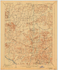
1906 Map of Sutherland
USGS Topo · Published 1930About this map
Panther Creek and its many branches dominate the landscape south of Owensboro, shaping a network of small agricultural settlements and rural parishes. The map reveals a high density of religious landmarks, from St Raphaels Church and St Martins Church in the north to Buck Creek Church and Woodward Valley Church further south. These centers served as the social anchors for scattered communities like Moseleyville, Handyville, and Andersonville.
Find a feature on this map
45 named features on this map. Tap any name to fly to it.
Don’t see what you’re looking for? This feature index may not catch every label — zoom into the map to look around manually.
Map Details
Editions of this 1906 Sutherland Map
3 editions found
Other maps of this area

1901 · Owensboro
USGS Topo · 1:62,500

1903 · Tell City
USGS Topo · 1:62,500

1905 · Newburg
USGS Topo · 1:62,500

1906 · Sutherland
USGS Topo · 1:62,500

1907 · Whitesville
USGS Topo · 1:62,500

1908 · Calhoun
USGS Topo · 1:62,500

1909 · Whitesville
USGS Topo · 1:62,500

1909 · Madisonville
USGS Topo · 1:62,500

1909 · Hartford
USGS Topo · 1:62,500

1909 · Central City
USGS Topo · 1:62,500