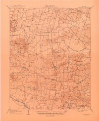
1906 Map of Sutherland
USGS Topo · Published 1945About this map
Green River and the meandering Panther Creek define the agrarian landscape of south-central Kentucky at the dawn of the twentieth century. This area, spanning the borders of Daviess, McLean, and Ohio Counties, reveals a dense network of rural post offices and community hubs. The Louisville and Nashville railroad acts as a central spine for the region, connecting the settlement of Utica with specialized stops like Browns Valley PO Crow Hickman Sta.
Find a feature on this map
52 named features on this map. Tap any name to fly to it.
Don’t see what you’re looking for? This feature index may not catch every label — zoom into the map to look around manually.
Map Details
Editions of this 1906 Sutherland Map
3 editions found
Other maps of this area

1901 · Owensboro
USGS Topo · 1:62,500

1903 · Tell City
USGS Topo · 1:62,500

1905 · Newburg
USGS Topo · 1:62,500

1906 · Sutherland
USGS Topo · 1:62,500

1907 · Whitesville
USGS Topo · 1:62,500

1908 · Calhoun
USGS Topo · 1:62,500

1909 · Whitesville
USGS Topo · 1:62,500

1909 · Madisonville
USGS Topo · 1:62,500

1909 · Hartford
USGS Topo · 1:62,500

1909 · Central City
USGS Topo · 1:62,500