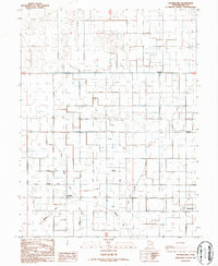
1986 Map of Sutherland
USGS Topo · Published 1987About this map
Agricultural development in Millard County's Sevier Desert is defined by an intricate network of irrigation projects shown in this mid-1980s revision. The settlement of Abraham sits near the convergence of the Little Abraham Canal and the Fullmer Canal, illustrating the vital role of water management in this arid landscape. Named canal and ditch systems, including Gronning, Wilson, Tolbert, and Henrie, carve the terrain into a grid of productive land. Near the small community of Sutherland, a local Cem (cemetery) serves as a quiet record of early residents who established these desert outposts. Other rural clusters like Sugarville and Woodrow are connected by a system of improved and unimproved roads, while numerous Spoil Banks along the waterways indicate the ongoing maintenance of the region's lifeblood infrastructure.
Find a feature on this map
22 named features on this map. Tap any name to fly to it.
Don’t see what you’re looking for? This feature index may not catch every label — zoom into the map to look around manually.
Map Details
Editions of this 1986 Sutherland Map
This is the sole edition of this map. No revisions or reprints were ever made.
Other maps of this area

1885 · Sevier Desert
USGS Topo · 1:250,000

1953 · Delta
USGS Topo · 1:250,000

1958 · Delta
USGS Topo · 1:250,000

1962 · Delta
USGS Topo · 1:250,000

1962 · Delta
USGS Topo · 1:62,500

1971 · Smelter Knolls East
USGS Topo · 1:24,000

1971 · Baker Hot Springs
USGS Topo · 1:24,000

1971 · Rain Lake
USGS Topo · 1:24,000

1971 · Fumarole Butte
USGS Topo · 1:24,000
1971 · Crafts Lake
USGS Topo · 1:24,000