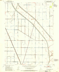
1952 Map of Sutter Causeway
USGS Topo · Published 1953About this map
The Sutter By-Pass dominates this 1952 topographic study, illustrating the intensive water management required for agriculture in the Sacramento Valley. This engineering feat, noted as being subject to inundation, is supported by infrastructure like the East Canal and a Pumping Station. The map shows a landscape defined by precise irrigation and reclamation efforts, where the Southern Pacific (Reclamation) rail line cuts a straight path toward the settlement of Subaco.
Find a feature on this map
30 named features on this map. Tap any name to fly to it.
Don’t see what you’re looking for? This feature index may not catch every label — zoom into the map to look around manually.
Map Details
Editions of this 1952 Sutter Causeway Map
4 editions found
Other maps of this area

1888 · Marysville
USGS Topo · 1:125,000

1891 · Marysville
USGS Topo · 1:125,000

1894 · Marysville
USGS Topo · 1:125,000

1895 · Marysville
USGS Topo · 1:125,000

1907 · Dunnigan
USGS Topo · 1:62,500

1910 · Knights Landing
USGS Topo · 1:31,680

1910 · Vernon
USGS Topo · 1:31,680

1910 · Nicolaus
USGS Topo · 1:31,680

1910 · Marcuse
USGS Topo · 1:31,680

1911 · Gilsizer Slough
USGS Topo · 1:31,680