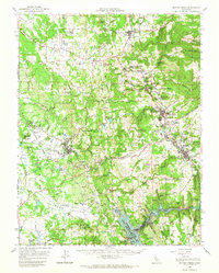
1962 Map of Sutter Creek
USGS Topo · Published 1967About this map
The Mother Lode region of the Sierra Nevada foothills is documented here in the early 1960s, revealing a landscape defined by its deep mining heritage. From the northern settlement of Plymouth down to Jackson, the map is densely populated with legendary claims such as the Central Eureka Mine, Bunker Hill Mine, and the Oneida Mine. These industrial features sit alongside a growing mid-century infrastructure, including the Amador Co High Sch and the Amador Co Airport.
Find a feature on this map
117 named features on this map. Tap any name to fly to it.
Don’t see what you’re looking for? This feature index may not catch every label — zoom into the map to look around manually.
Map Details
Editions of this 1962 Sutter Creek Map
2 editions found
Other maps of this area

1889 · Jackson
USGS Topo · 1:125,000

1891 · Sacramento
USGS Topo · 1:125,000

1891 · Placerville
USGS Topo · 1:125,000

1892 · Jackson
USGS Topo · 1:125,000

1892 · Sacramento
USGS Topo · 1:125,000

1892 · Placerville
USGS Topo · 1:125,000

1893 · Placerville
USGS Topo · 1:125,000

1893 · Sacramento
USGS Topo · 1:125,000

1894 · Lodi
USGS Topo · 1:125,000

1897 · Jackson
USGS Topo · 1:125,000