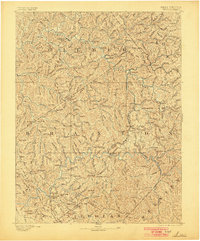
1893 Map of Sutton
USGS Topo · Published 1900About this map
The Little Kanawha River and Elk River wind through the heart of central West Virginia in this topographic survey from the late 19th century. This terrain is characterized by a dense network of watercourses and family-named knobs, such as Powell Knob and James Knob, which dictated the early settlement patterns of Gilmer and Braxton counties. Significant transportation infrastructure of the era is documented, including the West Virginia and Pittsburg Railroad and the Sutton Branch, which connected remote timber and coal regions to broader markets.
Find a feature on this map
94 named features on this map. Tap any name to fly to it.
Don’t see what you’re looking for? This feature index may not catch every label — zoom into the map to look around manually.
Map Details
Editions of this 1893 Sutton Map
3 editions found
Other maps of this area

1889 · Nicholas
USGS Topo · 1:125,000

1891 · Nicholas
USGS Topo · 1:125,000

1891 · Huntersville
USGS Topo · 1:125,000

1893 · Buckhannon
USGS Topo · 1:125,000

1893 · Sutton
USGS Topo · 1:125,000

1894 · Huntersville
USGS Topo · 1:125,000

1896 · Buckhannon
USGS Topo · 1:125,000

1897 · Buckhannon
USGS Topo · 1:125,000

1897 · Kanawha Falls
USGS Topo · 1:125,000

1900 · Kanawha Falls
USGS Topo · 1:125,000