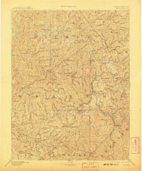
1893 Map of Sutton
USGS Topo · Published 1907About this map
The Elk River winds through the heart of this Central West Virginia landscape, anchoring the settlement of Sutton during a period of industrial expansion at the end of the nineteenth century. The arrival of the West Virginia and Pittsburg Railroad is evident, tracing a path through Burnsville and down toward the southern river valleys. This infrastructure connected previously isolated timber and milling communities like Bealls Mills, Stouts Mills, and Cedarville to wider markets.
Find a feature on this map
86 named features on this map. Tap any name to fly to it.
Don’t see what you’re looking for? This feature index may not catch every label — zoom into the map to look around manually.
Map Details
Editions of this 1893 Sutton Map
3 editions found
Other maps of this area

1889 · Nicholas
USGS Topo · 1:125,000

1891 · Nicholas
USGS Topo · 1:125,000

1891 · Huntersville
USGS Topo · 1:125,000

1893 · Buckhannon
USGS Topo · 1:125,000

1893 · Sutton
USGS Topo · 1:125,000

1894 · Huntersville
USGS Topo · 1:125,000

1896 · Buckhannon
USGS Topo · 1:125,000

1897 · Buckhannon
USGS Topo · 1:125,000

1897 · Kanawha Falls
USGS Topo · 1:125,000

1900 · Kanawha Falls
USGS Topo · 1:125,000