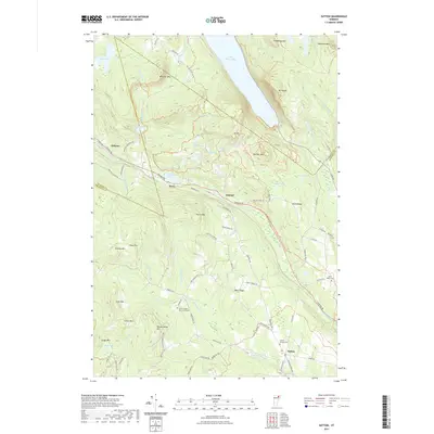
2021 Map of Sutton
USGS Topo · Published 2021About this map
Lake Willoughby dominates the northern reaches of this landscape, its southern tip framed by the steep rising slopes of Mt Pisgah and Mt Hor. The terrain is defined by a series of prominent peaks and ridges, including Hardscrabble Mtn, Wheeler Mtn, and Hedgehog Mtn, creating a dramatic backdrop for the rural settlements of Sutton and Orleans. Genealogists and local historians will find significant value in the documentation of family and community resting places, such as the Sutton Village Cem, North Ridge Cem, and the uniquely named Union House - King James Cem. The map traces the intricate water network of the Sutton River and Calendar Brook, alongside various upland ponds like Bean Pond and May Pond. This documentation reflects a highland environment where the road network, including Lynburke Rd and Underpass Rd, is dictated by the challenging verticality of the Vermont interior.
Find a feature on this map
88 named features on this map. Tap any name to fly to it.
Don’t see what you’re looking for? This feature index may not catch every label — zoom into the map to look around manually.
Map Details
Editions of this 2021 Sutton Map
This is the sole edition of this map. No revisions or reprints were ever made.
Other maps of this area

1919 · Lake Memphremagog
USGS Topo · 1:62,500

1920 · Derby
USGS Topo · 1:62,500

1923 · Lake Memphremagog
USGS Topo · 1:48,000

1924 · Island Pond
USGS Topo · 1:48,000

1925 · Memphremagog
USGS Topo · 1:62,500

1926 · Island Pond
USGS Topo · 1:62,500

1935 · Lyndonville
USGS Topo · 1:48,000

1939 · Lyndonville
USGS Topo · 1:62,500

1950 · Lake Champlain
USGS Topo · 1:250,000

1950 · Lewiston
USGS Topo · 1:250,000