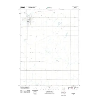
2011 Map of Sutton
USGS Topo · Published 2011About this map
Sutton serves as the primary hub of this eastern Clay County landscape, where the residential grid is anchored by the Sutton Post Office and bordered to the north by the meandering path of School Creek. The surrounding territory is defined by a rigorous mile-square section line road system, including routes like Road G and Road N, which organize the agricultural plains. Local history is preserved at the Sutton Cemetery and Calvary Cemetery, both located along Road X on the western edge of the community. Leisure and drainage patterns are visible south of the town center at the Fox Hollow Golf Course, while the broader geography is shaped by the headwaters of the North Fork Turkey Creek and Turkey Creek, which weave through the southern sections of the quadrangle.
Find a feature on this map
31 named features on this map. Tap any name to fly to it.
Don’t see what you’re looking for? This feature index may not catch every label — zoom into the map to look around manually.
Map Details
Editions of this 2011 Sutton Map
This is the sole edition of this map. No revisions or reprints were ever made.
Other maps of this area

1898 · York
USGS Topo · 1:125,000

1898 · Hebron
USGS Topo · 1:125,000

1899 · York
USGS Topo · 1:125,000

1955 · Lincoln
USGS Topo · 1:250,000

1957 · Lincoln
USGS Topo · 1:250,000

1958 · Lincoln
USGS Topo · 1:250,000

1969 · Bixby
USGS Topo · 1:24,000
1969 · Ong
USGS Topo · 1:24,000
1969 · Saronville
USGS Topo · 1:24,000
1969 · Grafton
USGS Topo · 1:24,000