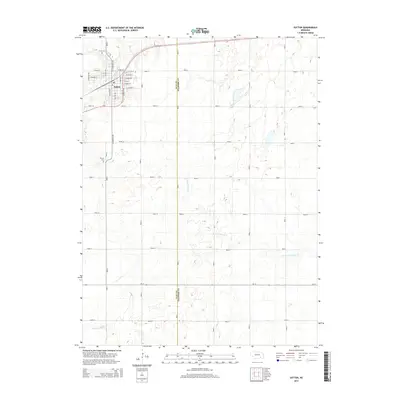
2014 Map of Sutton
USGS Topo · Published 2014About this map
Sutton serves as the primary hub of activity on the border between Clay and Fillmore Counties, where a grid of local thoroughfares such as N Saunders Ave and E Maple St define the town's residential and commercial core. The surrounding prairie landscape is deeply agricultural, carved by the meandering paths of School Cr and the N Fork Turkey Cr. Genealogists will find interest in the documented locations of Sutton Cem to the north and Calvary Cem to the south, both situated near the community center. This 2014 survey documents the enduring importance of transit corridors like Us 6 and Road 116 which facilitate the movement of goods through this rural landscape. The map's detailed topography reveals the subtle drainage patterns that feed into Turkey Cr, illustrating the relationship between the flat upland fields and the natural watercourses that define the region's geography.
Find a feature on this map
47 named features on this map. Tap any name to fly to it.
Don’t see what you’re looking for? This feature index may not catch every label — zoom into the map to look around manually.
Map Details
Editions of this 2014 Sutton Map
This is the sole edition of this map. No revisions or reprints were ever made.
Other maps of this area

1898 · York
USGS Topo · 1:125,000

1898 · Hebron
USGS Topo · 1:125,000

1899 · York
USGS Topo · 1:125,000

1955 · Lincoln
USGS Topo · 1:250,000

1957 · Lincoln
USGS Topo · 1:250,000

1958 · Lincoln
USGS Topo · 1:250,000

1969 · Bixby
USGS Topo · 1:24,000
1969 · Ong
USGS Topo · 1:24,000
1969 · Saronville
USGS Topo · 1:24,000
1969 · Grafton
USGS Topo · 1:24,000