
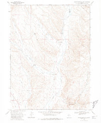
1968 Map of Swales Mountain NW
USGS Topo · Published 1971About this map
Maggie Creek and Little Jack Creek define the drainage patterns of this high desert terrain at the border of Elko and Eureka counties. The landscape is marked by the infrastructure of ranching and early resource exploration in the late 1960s, featuring the Coyote Ranch and various water sources critical for survival in the Great Basin. Named springs like Chicken Springs and the Rebholtz Well No 1 indicate the importance of water management for local operations.
Find a feature on this map
20 named features on this map. Tap any name to fly to it.
Don’t see what you’re looking for? This feature index may not catch every label — zoom into the map to look around manually.
Map Details
Editions of this 1968 Swales Mountain NW Map
2 editions found
Other maps of this area

1955 · McDermitt
USGS Topo · 1:250,000

1955 · Winnemucca
USGS Topo · 1:250,000

1958 · Winnemucca
USGS Topo · 1:250,000

1958 · Blue Basin
USGS Topo · 1:24,000

1958 · Huntsman Ranch
USGS Topo · 1:24,000
1958 · Swales Mountain
USGS Topo · 1:24,000

1959 · McDermitt
USGS Topo · 1:250,000

1962 · Winnemucca
USGS Topo · 1:250,000

1968 · Rodeo Creek NE
USGS Topo · 1:24,000

1968 · Welches Canyon
USGS Topo · 1:24,000