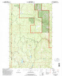
1992 Map of Swan Lake
USGS Topo · Published 1996About this map
Ferry Lake and Fish Lake sit at the heart of this high-elevation landscape in Ferry County, where the transition between the Colville National Forest and Okanogan National Forest is defined by sharp ridgelines and creek drainages. The topography is dominated by prominent peaks including Copper Mountain, Sheep Mountain, and Swan Butte, which overlook a network of seasonal streams and permanent water bodies like Copper Lakes. Historical land use is evident in the presence of a Quarry and a network of forest roads that follow the winding paths of Scatter Creek and Golden Harvest Creek. This 1990s record captures the region as it was managed for both resource extraction and conservation, showing the precise boundaries between national forests and the county line shared with Okanogan.
Find a feature on this map
17 named features on this map. Tap any name to fly to it.
Don’t see what you’re looking for? This feature index may not catch every label — zoom into the map to look around manually.
Map Details
Editions of this 1992 Swan Lake Map
This is the sole edition of this map. No revisions or reprints were ever made.
Other maps of this area

1904 · Republic
USGS Topo · 1:125,000

1948 · Republic
USGS Topo · 1:62,500

1951 · Wauconda
USGS Topo · 1:62,500

1951 · Republic
USGS Topo · 1:62,500

1953 · Seventeenmile Mtn.
USGS Topo · 1:62,500

1953 · Bald Knob
USGS Topo · 1:62,500

1954 · Okanogan
USGS Topo · 1:250,000

1958 · Okanogan
USGS Topo · 1:250,000

1958 · Aeneas
USGS Topo · 1:62,500

1984 · Republic
USGS Topo · 1:100,000