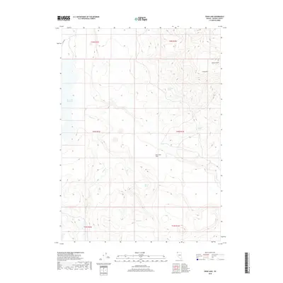
2018 Map of Swan Lake
USGS Topo · Published 2018About this map
Swan Lake Reservoir sits at the western edge of this high-desert landscape in northern Washoe County, where water sources dictate the character of the terrain. The map documents a network of vital desert water points including West Catnip Spring, Murdock Spring, and Antelope Spring, which have historically supported livestock and wildlife in this arid region. The topography is defined by the significant rise of Catnip Mtn and the broad, flat expanse of the Fish Creek Table. Seasonal drainage patterns are traced through Badger Cr and Fish Cr, which wind through the canyons and flats. This 2018 survey also marks the presence of Co Rte 34a, providing the primary transit route through this remote corner of Nevada near the Sheldon National Wildlife Refuge boundary.
Find a feature on this map
18 named features on this map. Tap any name to fly to it.
Don’t see what you’re looking for? This feature index may not catch every label — zoom into the map to look around manually.
Map Details
Editions of this 2018 Swan Lake Map
This is the sole edition of this map. No revisions or reprints were ever made.
Other maps of this area

1889 · Long Valley
USGS Topo · 1:250,000

1954 · Vya
USGS Topo · 1:250,000

1958 · Vya
USGS Topo · 1:250,000

1962 · Vya
USGS Topo · 1:250,000

1966 · Catnip Canyon
USGS Topo · 1:24,000

1966 · Bald Mountain
USGS Topo · 1:24,000
1966 · Rye Creek
USGS Topo · 1:24,000

1966 · Swan Lake
USGS Topo · 1:24,000

1966 · Badger Mtn NW
USGS Topo · 1:24,000

1966 · Massacre Lake
USGS Topo · 1:24,000