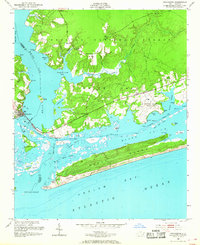
1952 Map of Swansboro
USGS Topo · Published 1968About this map
The White Oak River marks the divide between Onslow Co and Carteret Co as it spills into the Atlantic, shaping a complex landscape of tidal guts and maritime forest. In the early 1950s, the town of Swansboro serves as the focal point for coastal navigation, situated at the confluence of the river and the Intracoastal Waterway. This survey documents a critical period of military and civil infrastructure, from the sprawling U S Military Reservation (Bogue Airfield) to the Peletier Fire Tower watching over the Croatan National Forest.
Find a feature on this map
53 named features on this map. Tap any name to fly to it.
Don’t see what you’re looking for? This feature index may not catch every label — zoom into the map to look around manually.
Map Details
Editions of this 1952 Swansboro Map
4 editions found
Other maps of this area

1942 · Maysville
USGS Topo · 1:62,500

1942 · Swansboro
USGS Topo · 1:62,500

1948 · Maysville
USGS Topo · 1:62,500

1948 · Swansboro
USGS Topo · 1:62,500

1949 · Salter Path
USGS Topo · 1:24,000

1949 · Masontown
USGS Topo · 1:24,000

1951 · Salter Path
USGS Topo · 1:24,000

1951 · Masontown
USGS Topo · 1:24,000

1952 · Hubert
USGS Topo · 1:24,000

1952 · Swansboro
USGS Topo · 1:24,000