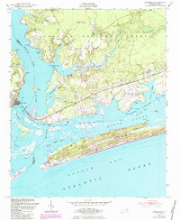
1952 Map of Swansboro
USGS Topo · Published 1984About this map
The White Oak River serves as a natural dividing line between Onslow and Carteret counties in this coastal survey, where the river meets the Atlantic Ocean at Bogue Inlet. The town of Swansboro sits at the western edge, overlooking a complex network of marshes and islands including Jones Island and Huggins Island. To the east, the landscape is defined by the Croatan National Forest and the US Military Reservation (Bogue Airfield), illustrating the mid-century intersection of conservation and national defense.
Find a feature on this map
49 named features on this map. Tap any name to fly to it.
Don’t see what you’re looking for? This feature index may not catch every label — zoom into the map to look around manually.
Map Details
Editions of this 1952 Swansboro Map
4 editions found
Other maps of this area

1942 · Maysville
USGS Topo · 1:62,500

1942 · Swansboro
USGS Topo · 1:62,500

1948 · Maysville
USGS Topo · 1:62,500

1948 · Swansboro
USGS Topo · 1:62,500

1949 · Salter Path
USGS Topo · 1:24,000

1949 · Masontown
USGS Topo · 1:24,000

1951 · Salter Path
USGS Topo · 1:24,000

1951 · Masontown
USGS Topo · 1:24,000

1952 · Hubert
USGS Topo · 1:24,000

1952 · Swansboro
USGS Topo · 1:24,000