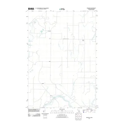
2011 Map of Swanson
USGS Topo · Published 2011About this map
The Menominee River forms a defining southern boundary for this region on the border between Michigan and Wisconsin, where the landscape is etched by a dense network of small waterways and drainage basins. Local heritage is grounded in rural clusters such as Swanson, Star Corners, and Kells, which reflect the early settlement patterns of Marinette County. Genealogists will find particular value in the documentation of the Swedish Methodist Cemetery and Bethesda Lutheran Cemetery, markers of the ethnic and religious communities that cleared this land. The terrain is characterized by numerous glacial remnants, including Swanson Lake, Linnbeck Lake, and Johnson Lake, which feed into tributaries like Harding Creek and Phillips Creek. These watercourses eventually join the larger river system, illustrating the natural drainage towards the Menominee. The map provides a clear view of the road grid as it existed in 2011, connecting isolated homesteads to the small hamlets of Longrie and Koss.
Find a feature on this map
22 named features on this map. Tap any name to fly to it.
Don’t see what you’re looking for? This feature index may not catch every label — zoom into the map to look around manually.
Map Details
Editions of this 2011 Swanson Map
This is the sole edition of this map. No revisions or reprints were ever made.
Other maps of this area

1939 · Pembine
USGS Topo · 1:48,000

1942 · Wausaukee
USGS Topo · 1:48,000

1947 · Pembine
USGS Topo · 1:48,000

1947 · Wausaukee
USGS Topo · 1:48,000

1949 · Stephenson
USGS Topo · 1:48,000

1954 · Escanaba
USGS Topo · 1:250,000

1957 · Escanaba
USGS Topo · 1:250,000

1958 · Escanaba
USGS Topo · 1:250,000

1963 · Pembine
USGS Topo · 1:62,500

1963 · Powers
USGS Topo · 1:62,500