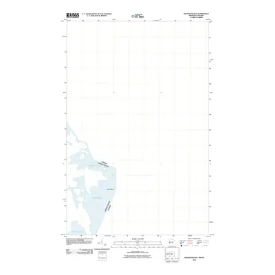
2010 Map of Swansons Bay
USGS Topo · Published 2010About this map
Sand Point Lake dominates the southwestern quadrant of this 2010 survey, representing a remote aquatic landscape along the international border. The boundary between the United States and Canada bisects the water, tracing a path north from Sand Point Lake toward the interior of the Rainy River District. Amidst this vast expanse of water, Burnt Island stands as a prominent terrestrial landmark. The map's sparse labels emphasize the wilderness character of the region, where natural features rather than human settlements define the geography. This document illustrates the intersection of national jurisdictions within the shared water systems of the North Woods, where the transition from water to land is marked by unnamed peninsulas and intricate shorelines.
Find a feature on this map
4 named features on this map. Tap any name to fly to it.
Don’t see what you’re looking for? This feature index may not catch every label — zoom into the map to look around manually.
Map Details
Editions of this 2010 Swansons Bay Map
This is the sole edition of this map. No revisions or reprints were ever made.
Other maps of this area

1954 · International Falls
USGS Topo · 1:250,000

1957 · International Falls
USGS Topo · 1:250,000

1958 · International Falls
USGS Topo · 1:250,000

1963 · Snow Bay
USGS Topo · 1:24,000

1963 · Redhorse Bay
USGS Topo · 1:24,000

1963 · Crane Lake
USGS Topo · 1:24,000

1967 · Hale Bay
USGS Topo · 1:24,000

1967 · Johnson Lake
USGS Topo · 1:24,000
1978 · Brule Narrows
USGS Topo · 1:100,000
1978 · Crane Lake
USGS Topo · 1:100,000