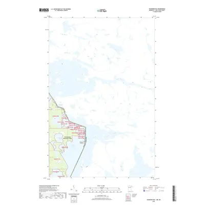
2019 Map of Swansons Bay
USGS Topo · Published 2019About this map
Voyageurs National Park dominates the western portion of this 2019 survey, highlighting a watery wilderness at the border of Minnesota and Ontario. The landscape is defined by the complex aquatic intersection of Sand Point Lake and the northern reaches of Swansons Bay, where the United States of America Canada boundary winds through open water and rocky outcrops. The map illustrates the intricate shoreline of the Namakan Narrows and the solitary position of Burnt Island, reflecting the remote and preserved character of this international borderland. This modern geospatial record emphasizes the protected natural boundaries and hydrographic patterns that have shaped travel and recreation in this northern lake country for generations.
Find a feature on this map
8 named features on this map. Tap any name to fly to it.
Don’t see what you’re looking for? This feature index may not catch every label — zoom into the map to look around manually.
Map Details
Editions of this 2019 Swansons Bay Map
This is the sole edition of this map. No revisions or reprints were ever made.
Other maps of this area

1954 · International Falls
USGS Topo · 1:250,000

1957 · International Falls
USGS Topo · 1:250,000

1958 · International Falls
USGS Topo · 1:250,000

1963 · Snow Bay
USGS Topo · 1:24,000

1963 · Redhorse Bay
USGS Topo · 1:24,000

1963 · Crane Lake
USGS Topo · 1:24,000

1967 · Hale Bay
USGS Topo · 1:24,000

1967 · Johnson Lake
USGS Topo · 1:24,000
1978 · Brule Narrows
USGS Topo · 1:100,000
1978 · Crane Lake
USGS Topo · 1:100,000