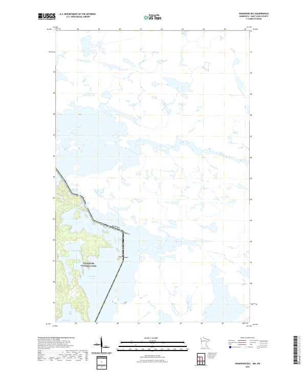
2022 Map of Swansons Bay
USGS Topo · Published 2022About this map
Voyageurs National Park encompasses the southwestern portion of this map, preserving a landscape defined by the aquatic labyrinth of northern Minnesota. This remote border region is dominated by major water bodies including Swansons Bay and Sand Point Lake, which serve as critical corridors in a territory where land is secondary to water. The international boundary between the Canada and the United States threads through these waterways, specifically passing through the constricted channel of Namakan Narrows. Unlike more developed regions, the area is characterized by intricate shorelines and isolated landforms like Burnt Island, reflecting a wilderness character that has remained remarkably consistent. The map detail highlights the intersection of township and range lines, such as t69n r17w and t68n r17w, within the protected park boundaries, illustrating how early surveying systems persist even in modern conservation areas.
Find a feature on this map
9 named features on this map. Tap any name to fly to it.
Don’t see what you’re looking for? This feature index may not catch every label — zoom into the map to look around manually.
Map Details
Editions of this 2022 Swansons Bay Map
This is the sole edition of this map. No revisions or reprints were ever made.
Other maps of this area

1954 · International Falls
USGS Topo · 1:250,000

1957 · International Falls
USGS Topo · 1:250,000

1958 · International Falls
USGS Topo · 1:250,000

1963 · Snow Bay
USGS Topo · 1:24,000

1963 · Redhorse Bay
USGS Topo · 1:24,000

1963 · Crane Lake
USGS Topo · 1:24,000

1967 · Hale Bay
USGS Topo · 1:24,000

1967 · Johnson Lake
USGS Topo · 1:24,000
1978 · Brule Narrows
USGS Topo · 1:100,000
1978 · Crane Lake
USGS Topo · 1:100,000