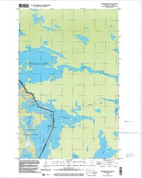
1999 Map of Swansons Bay
USGS Topo · Published 2003About this map
Voyageurs National Park defines the southern portion of this international border landscape, where the waters of Namakan Lake meet the United States-Canada boundary. The map illustrates a complex network of glacial lakes and channels, including the bottleneck of the Namakan Narrows and the flow of the Namakan River through Lady Rapids. As a snapshot of the late 20th century, the sheet documents the transition from Minnesota's St. Louis County to Ontario's Rainy River District. The presence of numerous designated Campsites around Redhorse Bay and Swansons Bay highlights the area's established role as a protected wilderness and recreational destination. Prominent landmarks such as Burnt Island and Sand Point serve as key navigational markers for those tracing the historical water routes of this northern borderland.
Find a feature on this map
22 named features on this map. Tap any name to fly to it.
Don’t see what you’re looking for? This feature index may not catch every label — zoom into the map to look around manually.
Map Details
Editions of this 1999 Swansons Bay Map
This is the sole edition of this map. No revisions or reprints were ever made.
Other maps of this area

1954 · International Falls
USGS Topo · 1:250,000

1957 · International Falls
USGS Topo · 1:250,000

1958 · International Falls
USGS Topo · 1:250,000

1963 · Snow Bay
USGS Topo · 1:24,000

1963 · Redhorse Bay
USGS Topo · 1:24,000

1963 · Crane Lake
USGS Topo · 1:24,000

1967 · Hale Bay
USGS Topo · 1:24,000

1967 · Johnson Lake
USGS Topo · 1:24,000
1978 · Brule Narrows
USGS Topo · 1:100,000
1978 · Crane Lake
USGS Topo · 1:100,000