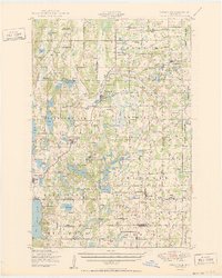
1950 Map of Swanville
USGS Topo · Published 1950About this map
Swanville stands as a central hub at the junction of the Soo Line and Northern Pacific railroads, anchoring a landscape defined by an intricate network of lakes and small agricultural communities. This 1950 survey reveals the rural character of the borderlands between Todd, Morrison, and Stearns counties, where the Swan River and Two Rivers drain a terrain dotted with glacial features like the Big Marsh. The map provides significant genealogical value, documenting numerous numbered schoolhouses, such as School No 65 and School No 94, alongside local civic landmarks like the Culdrum Town Hall and Elmdale Town Hall. From the lakeside community of Pleasant Beach on Birch Lake to the scattered parishes and cemeteries like the GAR Cemetery near Burtrum, the document captures a mid-century period of settled dairy country and small-town life in central Minnesota.
Find a feature on this map
117 named features on this map. Tap any name to fly to it.
Don’t see what you’re looking for? This feature index may not catch every label — zoom into the map to look around manually.
Map Details
Editions of this 1950 Swanville Map
2 editions found
Other maps of this area

1947 · Flensburg
USGS Topo · 1:25,000

1948 · Belle Prairie
USGS Topo · 1:62,500

1948 · Cushing
USGS Topo · 1:62,500

1948 · Little Falls
USGS Topo · 1:62,500

1950 · Swanville
USGS Topo · 1:62,500

1950 · Belle Prairie
USGS Topo · 1:62,500

1950 · Little Falls
USGS Topo · 1:62,500

1950 · Cushing
USGS Topo · 1:62,500

1951 · Flensburg
USGS Topo · 1:25,000

1953 · Brainerd
USGS Topo · 1:250,000