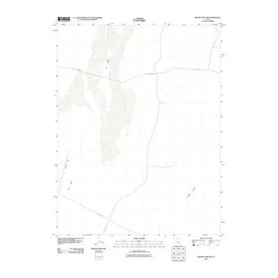
2011 Map of Swasey Peak SW
USGS Topo · Published 2011About this map
Tule Valley dominates this arid interior landscape of Millard County, Utah, where a sparse network of dirt roads serves as the primary connection through a vast desert basin. The topography is defined by the alluvial flats of the valley floor, flanked by the Smelter Hills to the west and the rising slopes of the Middle Range to the east. Historically significant routes cross this region, notably Old 6 and 50 in the southern portion, which reflects the evolution of early transcontinental travel before more modern alignments. Access into the more mountainous terrain is provided by the aptly named Death Canyon Rd, while Tule Valley Rd follows the north-south axis of the basin floor. This map illustrates a remote corner of the Great Basin where the landscape is shaped primarily by drainage patterns and seasonal washes rather than permanent settlements.
Find a feature on this map
6 named features on this map. Tap any name to fly to it.
Don’t see what you’re looking for? This feature index may not catch every label — zoom into the map to look around manually.
Map Details
Editions of this 2011 Swasey Peak SW Map
This is the sole edition of this map. No revisions or reprints were ever made.
Other maps of this area

1908 · Fish Springs
USGS Topo · 1:250,000

1910 · Fish Springs
USGS Topo · 1:250,000

1953 · Delta
USGS Topo · 1:250,000

1958 · Delta
USGS Topo · 1:250,000

1959 · Cowboy Pass
USGS Topo · 1:62,500

1960 · Notch Peak
USGS Topo · 1:62,500

1960 · Conger Mountain
USGS Topo · 1:62,500

1962 · Delta
USGS Topo · 1:250,000

1972 · Swasey Peak SW
USGS Topo · 1:24,000
1972 · Swasey Peak
USGS Topo · 1:24,000