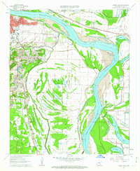
1961 Map of Sweet Home
USGS Topo · Published 1962About this map
Adams Field Municipal Airport anchors the north of this early 1960s survey, marking a period of expansion for the state capital. The Arkansas River curves sharply through the center of the sheet, bounded by a series of protective levees and flanked by the oxbows of Old River Lake and Willow Beach Lake. On the southern outskirts of Little Rock, the industrial landscape of Granite Mountain and its Mine Dump give way to smaller residential clusters such as College Station (Geneva PO) and Picron Hill.
Find a feature on this map
44 named features on this map. Tap any name to fly to it.
Don’t see what you’re looking for? This feature index may not catch every label — zoom into the map to look around manually.
Map Details
Editions of this 1961 Sweet Home Map
4 editions found
Other maps of this area

1891 · Little Rock
USGS Topo · 1:125,000

1893 · Little Rock
USGS Topo · 1:125,000

1935 · Mc Almont
USGS Topo · 1:24,000

1935 · Little Rock
USGS Topo · 1:24,000

1935 · Sweet Home
USGS Topo · 1:24,000

1935 · North Little Rock
USGS Topo · 1:24,000

1935 · Alexander
USGS Topo · 1:48,000

1939 · Keo
USGS Topo · 1:31,680

1940 · Woodson
USGS Topo · 1:31,680

1941 · Alexander
USGS Topo · 1:62,500