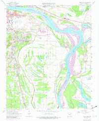
1961 Map of Sweet Home
USGS Topo · Published 1982About this map
Adams Field Municipal Airport and the expanding riverfront of Little Rock dominate the northern landscape of this survey, which captures a critical period of industrial and infrastructure development south of the city. The Arkansas River winds through the center of the sheet, featuring the David D Terry Lock and Dam and the Little Rock Port as the waterway was modernized for commerce. To the south, the topography shifts from the developed industrial zones of Genevia and Picron Hill toward the low-lying wetlands of Big Rock Island and Steele Bend. The map documents numerous rural institutions essential to local genealogy, including the White Rock Mission, Pfeifer Sch, and Freeman Cem, alongside the operations of the St Louis Southwestern and Missouri Pacific railroads.
Find a feature on this map
48 named features on this map. Tap any name to fly to it.
Don’t see what you’re looking for? This feature index may not catch every label — zoom into the map to look around manually.
Map Details
Editions of this 1961 Sweet Home Map
4 editions found
Other maps of this area

1891 · Little Rock
USGS Topo · 1:125,000

1893 · Little Rock
USGS Topo · 1:125,000

1935 · Mc Almont
USGS Topo · 1:24,000

1935 · Little Rock
USGS Topo · 1:24,000

1935 · Sweet Home
USGS Topo · 1:24,000

1935 · North Little Rock
USGS Topo · 1:24,000

1935 · Alexander
USGS Topo · 1:48,000

1939 · Keo
USGS Topo · 1:31,680

1940 · Woodson
USGS Topo · 1:31,680

1941 · Alexander
USGS Topo · 1:62,500