
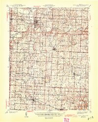
1945 Map of Sweet Springs
USGS Topo · Published 1945About this map
The Blackwater River winds through this central Missouri landscape, where the borders of Saline, Pettis, Johnson, and Lafayette counties meet. This region, surveyed just before the 1940s, is defined by a dense network of one-room schoolhouses and rural churches that served a farming population before the consolidation of the mid-20th century. Named landmarks like Elder Ridge and Bleak Mound rise above the drainage basins of Salt Pond Creek and Davis Creek. Settlement is concentrated along the Missouri Pacific railroad line, which connects the towns of La Monte, Dresden, and Hughesville. A notable industrial feature is the Pumping Station situated north of the Pettis County line. The map captures the transition of the local economy as it navigated between rail-reliant trade and the emerging influence of early thoroughfares like Highway 40.
Find a feature on this map
72 named features on this map. Tap any name to fly to it.
Don’t see what you’re looking for? This feature index may not catch every label — zoom into the map to look around manually.
Map Details
Editions of this 1945 Sweet Springs Map
2 editions found
Other maps of this area

1885 · Warrensburg
USGS Topo · 1:125,000

1887 · Sedalia
USGS Topo · 1:125,000

1887 · Warrensburg
USGS Topo · 1:125,000

1889 · Lexington
USGS Topo · 1:125,000

1890 · Marshall
USGS Topo · 1:125,000

1892 · Marshall
USGS Topo · 1:125,000

1894 · Sedalia
USGS Topo · 1:125,000

1894 · Warrensburg
USGS Topo · 1:125,000

1901 · Marshall
USGS Topo · 1:125,000

1917 · Knobnoster
USGS Topo · 1:62,500