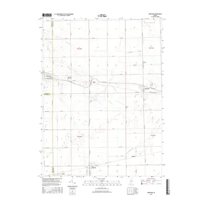
2016 Map of Sweetser
USGS Topo · Published 2016About this map
Swayzee and Converse anchor this 2016 survey of the central Indiana farm belt, where Grant, Miami, and Howard Counties meet. The landscape is defined by a dense network of agricultural drainage systems, including Potter Ditch, Rich Ditch, and Leisure Ditch, which feed into the meandering course of Pipe Cr. These engineered watercourses transformed the naturally wet prairie into some of the most productive cropland in the Midwest. The map documents several small crossroads settlements, from Mier at the junction of Delphi Pike and N 800 W to the quiet rail-adjacent hamlets of Herbst and Sims. Genealogists will find several burial grounds recorded here, such as Maple Grove Cem, Thraikill Cem, and the Independent Order of Odd Fellows Cem near Converse. Of particular interest is the Sweetser-Switch Trl, showing the repurposing of former rail infrastructure into modern recreational paths.
Find a feature on this map
90 named features on this map. Tap any name to fly to it.
Don’t see what you’re looking for? This feature index may not catch every label — zoom into the map to look around manually.
Map Details
Editions of this 2016 Sweetser Map
This is the sole edition of this map. No revisions or reprints were ever made.
Other maps of this area

1953 · La Fontaine
USGS Topo · 1:24,000

1953 · Somerset
USGS Topo · 1:24,000

1953 · Peoria
USGS Topo · 1:24,000

1953 · Muncie
USGS Topo · 1:250,000

1956 · Muncie
USGS Topo · 1:250,000

1960 · Point Isabel
USGS Topo · 1:24,000

1960 · Fairmount
USGS Topo · 1:24,000

1960 · Greentown
USGS Topo · 1:24,000

1961 · Marion
USGS Topo · 1:24,000
1962 · Amboy
USGS Topo · 1:24,000