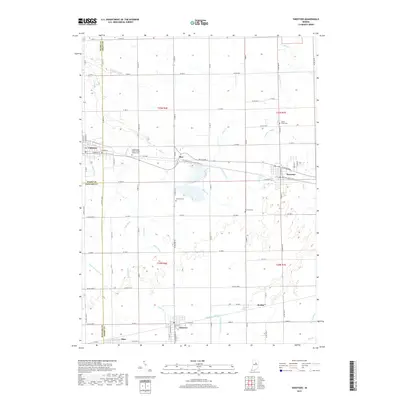
2019 Map of Sweetser
USGS Topo · Published 2019About this map
Swayzee and Sweetser anchor this agricultural landscape in Grant County, reflecting a history tied to the interurban and rail corridors of north-central Indiana. The town of Converse sits at the western edge, while smaller nodes like Mier, Herbst, and Sims mark the intersections of rural life. A complex network of drainage infrastructure, including Potter Ditch and Sweetser Ditch, crisscrosses the township lines to manage the headwaters of Pipe Cr and Taylor Cr.
Find a feature on this map
38 named features on this map. Tap any name to fly to it.
Don’t see what you’re looking for? This feature index may not catch every label — zoom into the map to look around manually.
Map Details
Editions of this 2019 Sweetser Map
This is the sole edition of this map. No revisions or reprints were ever made.
Other maps of this area

1953 · La Fontaine
USGS Topo · 1:24,000

1953 · Somerset
USGS Topo · 1:24,000

1953 · Peoria
USGS Topo · 1:24,000

1953 · Muncie
USGS Topo · 1:250,000

1956 · Muncie
USGS Topo · 1:250,000

1960 · Point Isabel
USGS Topo · 1:24,000

1960 · Fairmount
USGS Topo · 1:24,000

1960 · Greentown
USGS Topo · 1:24,000

1961 · Marion
USGS Topo · 1:24,000
1962 · Amboy
USGS Topo · 1:24,000