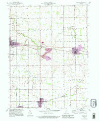
1992 Map of Sweetser
USGS Topo · Published 1995About this map
The industrial and agricultural landscape of central Indiana is detailed in this 1990s-era revision, showcasing the corridor between Converse and Sweetser. The Central Railroad of Indianapolis serves as a primary transit vein, threading through several small settlements including Mier and Swayzee. This edition highlights late-20th-century development, particularly around the Oak Hill High Sch and expanded residential areas in purple. Local history and genealogy are anchored by several notable landmarks, such as Richland Chapel, Taylors Creek Ch, and the IOOF Cem. The drainage patterns of the region are defined by Pipe Creek and its many tributaries, including Little Pipe Creek and Stony Creek, which cross the township lines of Richland, Pleasant, and Sims.
Find a feature on this map
43 named features on this map. Tap any name to fly to it.
Don’t see what you’re looking for? This feature index may not catch every label — zoom into the map to look around manually.
Map Details
Editions of this 1992 Sweetser Map
This is the sole edition of this map. No revisions or reprints were ever made.
Other maps of this area

1953 · La Fontaine
USGS Topo · 1:24,000

1953 · Somerset
USGS Topo · 1:24,000

1953 · Peoria
USGS Topo · 1:24,000

1953 · Muncie
USGS Topo · 1:250,000

1956 · Muncie
USGS Topo · 1:250,000

1960 · Point Isabel
USGS Topo · 1:24,000

1960 · Fairmount
USGS Topo · 1:24,000

1960 · Greentown
USGS Topo · 1:24,000

1961 · Marion
USGS Topo · 1:24,000
1962 · Amboy
USGS Topo · 1:24,000